
Byron Shire Coastal Zone Hazard Definition Study
The coastal zone of Byron Shire has a history of erosion and inundation related to ocean storm tides and wave attack.
The coastal zone of Byron Shire has a history of erosion and inundation related to ocean storm tides and wave attack.
A village at New Brighton was lost in the 1970’s and, at Byron Bay, erosion of Belongil Spit and flooding of Belongil Creek due to elevated ocean levels and stormwater runoff are severe problems.
We undertook a detailed technical coastal and ocean process investigation and Coastline Hazard Definition Study in line with the NSW Government’s Coastal Policy (1997) and its Coastline Management Manual (1990).
This study is the first stage in development and implementation of a Coastline Management Plan for the Shire. Hazards include: long term (non-reversible) shoreline recession and oceanic inundation associated with storm tides, sea level rise (climate change) and a prevailing net sand loss alongshore; short term (reversible) beach erosion; and stormwater discharge impacts.
These were assessed for the required planning timeframes for each of four major beach compartments. Cumulative hazard zones were defined for immediate, 50 year and 100 year planning periods and mapped using GIS techniques. The report was adopted by the Byron Shire Council in late 2000 and forms the basis for consideration of future coastal works and management options for the Shire’s coastline.
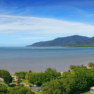
We have led the development of coastal hazard maps (sea level rise, storm tide inundation and erosion) for the City of Cairns in Far North Queensland and used this information to undertake a risk assessment of assets and infrastructure of the City under three timeframes (current, 2050 and 2100), incorporating climate change projections.
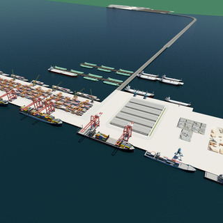
The purpose of this Preliminary Feasibility assessment was to establish at a high level the nature and volume of cargo demand, the technical requirements to support this volume, the marine and port facility requirements, broad environmental and metocean impacts, and quantified investment returns.
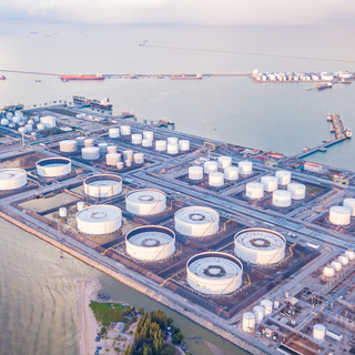
We were commissioned by Puma Energy to conduct a HAZOP Study to review the FEED safety design for the current North Vietnam Bitumen Terminal.

Bengal Port Private Limited signed concession Agreements with the Government of West Bengal to develop finance, construct, manage, operate and maintain a Special Economic Zone