The next generation of navigation solutions
The growing size and number of vessels in the global cruise fleet requires the industry to set new standards for navigation technology to ensure it meet the highest standards of safety.
The growing size and number of vessels in the global cruise fleet requires the industry to set new standards for navigation technology to ensure it meet the highest standards of safety.
5 April 2023
This thought leadership article first published in Cruise & Ferry Review’s (CFR) Spring/Summer 2023 issue by Rebecca Gibson, CFR's News Editor. A link to the full printed Review is here: full digital edition
It is important to consider the impact this growth has on being able to safely operate and navigate these vessels, particularly when they call at a port or cruise terminal.
Ports are becoming more crowded as they welcome more ships and bigger vessels, which can cause challenges if they have either limited shoreside infrastructure or restricted water spaces. In addition, many port operators are still facing significant resourcing and workforce challenges. To overcome these issues, ports need to update and expand their infrastructure and both shipboard crews and port-side operators require further training to allow them to safely manage operations for larger vessels.
Meanwhile, cruise ship operators are working with their most experienced navigators to select integrated bridge systems (IBS) and other advanced navigational technologies for their new ships to ensure they will operate to the highest safety standards.
As digital tools and technologies empower ship operators with new capabilities, they will be able to link voyage planning, processing and execution systems to radar, automatic identification systems, GPS and compasses. This will provide bridge teams with optimal situational awareness and ultimately ensure the safe passage of the vessel.
For example, Saga Cruises sought advice from classification society Lloyd’s Register when selecting the IBS for its $400 million Spirit-class ships. The end solution included a dual electronic chart display and information system (ECDIS), speed pilot, track pilot and digital navigation workstations for voyage planning and checking routes for safety. The vessels have S-band and X-band main radar, as well as stern radar for tracking hazards and surround ship traffic.
Once ship operators are using ECDIS as the primary means of navigation, crew members will no longer need to physically gather data from multiple sources, enabling them to prioritise other safety-critical tasks instead. This also minimises the risk of human error, ensuring that navigational data is as accurate as possible, negating the risk of collisions or groundings. This is crucial for cruise vessels as they are at a greater risk of incident, particularly in narrow or shallow waterways.
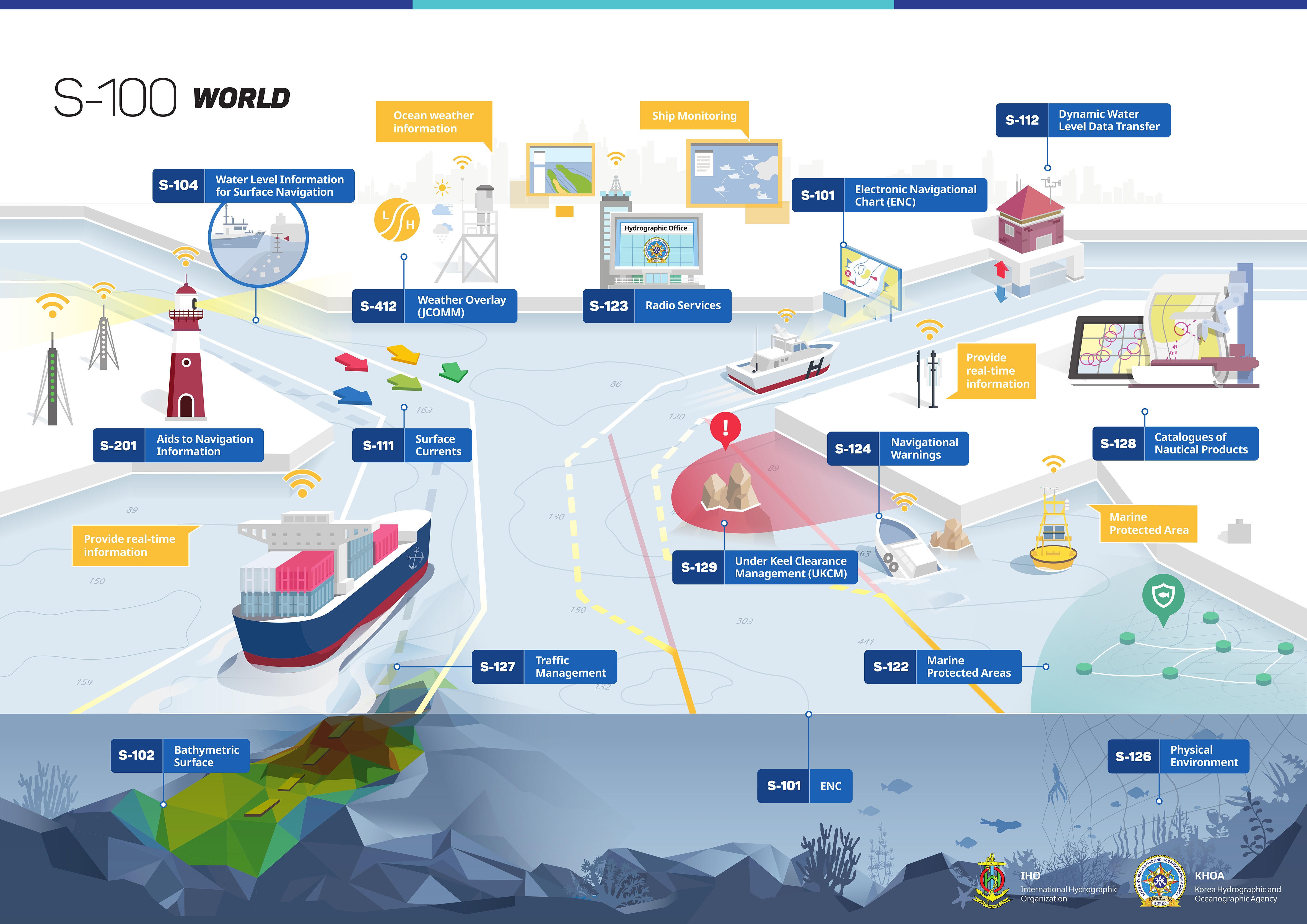
To ensure that data is accurate, the industry must also move to a new storage and distribution model. The S-57 International Hydrographic Office (IHO) standard for digital hydrographic data is the current framework used for exchanging data between national hydrographic offices and manufacturers, mariners and other data users. It has been in use since 1992 and is fundamentally designed for a human interface as the end user, so it is limited in its adaptability.
This has become particularly apparent as the shipping industry has embraced ECDIS and benefitted from up-to-date electronic navigational charts enable them to plan voyages more effectively. In recognition of the wide availability of new navigation products that can use richer and more dynamic environmental data, as well as the need to ensure ECDIS is accurate, the IHO has introduced the S-100, otherwise known as the Universal Hydrographic Data Model.
The S-100 model is inherently more flexible, offering provision for more granular gridded data and imagery, time-varying data, enhanced metadata and multiple coding formats. It uses machine readable catalogues, which will lead to plug-and-play systems that make it easier to update data standards and ECDIS. As a result, the framework enables more precise navigation in restricted waterways. It also provides a platform for much greater situational awareness and realism within the models used in navigation training systems onboard and onshore.
The S-102 High Resolution Bathymetry specification is an example of one of the maturing S-100 products. Preparing bathymetric data for charts typically involves taking survey data and using it to generate areas in range bands and separated by contours. To keep the volume of data down and the presentation uncluttered, the band ranges and contours in S-57 are fairly wide. However, this can place large navigable areas out of bounds if the safety depth does not correspond to one of these levels.
S-102 preserves a lot more survey data, with depth information available to the order of centimetres. The availability of such a fine level of detail means that the depth band restriction can be removed, allowing ship operators to develop precise plans for navigating a safe passage. Several cruise operators are actively investigating how S-100 environmental data can be used to support more precise navigation to enable them to open up new cruise destinations and expanding itineraries for larger ships.
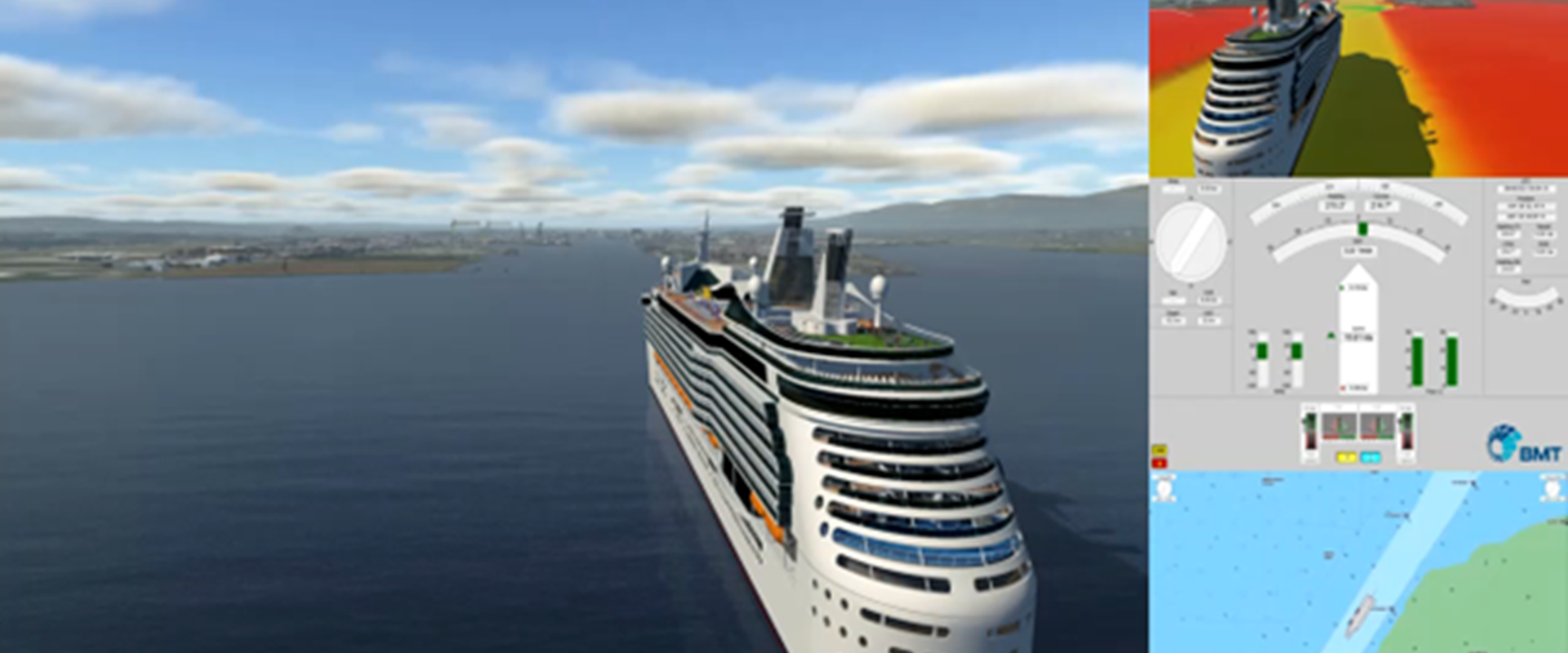
One example of S-100 exploitation is the BMT REMBRANDT S-100-enabled navigation simulator system, which has been used by cruise ship operators both onboard and ashore in conjunction with S-102 bathymetry data to explore new cruise destinations.
As smart bridge automation increases, the cruise ship and port industries are likely to increasingly rely on a full digital world model, with IHO S-100 as part of its core. With this approach, they will be able to meet the highest requirements for maritime situational awareness and collision avoidance.

Since joining BMT in 1992, Phil has held various managerial and executive appointments within BMT’s global management consultancy. He currently leads the Simulation and Training Services business at BMT.
His extensive work in e-Navigation, Traffic Simulation, Digital Twinning and Digital Reconstruction Forensics has led to the world’s leading ship operators and statutory marine accident investigation bodies to adopt BMT navigation simulators for port planning and navigation training. Users include Shell, the U.S. National Transportation Safety Board and counterparts in the U.K., Australia and the Netherlands. Phil is also currently leading a number of joint industry developments in Autonomous Surface Vessels, Artificial Intelligence, Deep Learning and Machine Vision Capabilities and the impacts on Future Port Design.
Phil has held several Directorships with the Transport, Offshore and Marine Surveys divisions at BMT. Prior to joining BMT, he worked in underwater acoustics at BAE Systems and as a Professor at the Department of Aerospace and Ocean Engineering at Virginia Tech, U.S.A.
He has received a Civil and Structural Engineering doctorate from Newcastle University and an MBA from Durham University. Phil is registered as a Chartered Director with the UK’s Institute of Directors.

Chloe Yarrien
Maritime Autonomous Systems (MAS) are moving from concept to operational reality. Across defence and commercial maritime sectors, organisations are exploring how autonomy can improve operational effectiveness, increase persistence, reduce risk to personnel and enable new ways of working.

Dr Thomas Beard - UK / Europe
John Bensalhia from the IMarEST talks to Thomas Beard and Jake Rigby, about the potential benefits, difficulties and future outcomes of making nuclear-powered vessels a reality.

Panagiotis Kasionis
Coal cargoes remain a high-risk “routine” trade. Panagiotis Kasionis, explores key risks, regulatory changes and practical insights for managing exposure across the supply chain.

Dr Thomas Beard - UK / Europe
As shipping transitions to low‑carbon fuels, safety has become the defining challenge. This interview by RINA's The Naval Architect, explores how alternative fuels such as methanol, ammonia, hydrogen and LNG introduce new risks, and how smart vessel design, layered protection and crew competence are essential to delivering decarbonisation without compromising safety.