
Relocation only option for Solomon Islands provincial capital
Dr Philip Haines discusses the partnership to develop a climate change adaptation plan in the Solomon Islands.
Dr Philip Haines discusses the partnership to develop a climate change adaptation plan in the Solomon Islands.
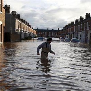
In response to the overshadowing risk of tsunami events and the emerging challenges associated with sea-level rise, a community on the tiny coral atoll of Taro Island in the Solomon Islands chooses to relocate their homes and lives to higher ground on the adjacent mainland. While relocation of villages under threat from natural hazards is not new in the Pacific, this is the first time a provincial capital will attempt to relocate because of climate change and other coastal risks.
We partnered with Buckley Vann town planners and the School of Civil Engineering at the University of Queensland to collaborate with the Australian Government’s Pacific-Australia Climate Change Science and Adaptation Planning (PACCSAP) programme.
The team developed an Integrated Climate Change Adaptation Plan for Taro Island and the surrounding area of Choiseul Bay, including a detailed schedule of works for relocation of the Taro Island community to the adjacent mainland, along with a masterplan for the new town and a comprehensive planning scheme to regulate future development.
The adaptation plan has utilised the outcomes of extensive consultation that was carried out with local communities, relevant stakeholders and government authorities at both provincial and national levels. There is near-unanimous support for the relocation plan by the Taro Island community and management. Recent evacuations of the island in response to local tsunami warnings have helped heighten awareness of the vulnerability of the existing town.
As the relocation process will require significant infrastructure investment, authorities will look to the support of international donors to safely transition the Taro Island community to higher ground. Recognising that relocation of the community will take 20 years or more, the climate change adaptation plan developed also outlines a range of ‘stop gap’ measures to help reduce damage and loss of life if significant events occur in the interim. We have included preparing a tsunami emergency response plan and structural reinforcement of some critical assets.
Location
Choiseul Bay is located at the northern end of Choiseul Island (known locally as Lauru), within the Solomon Islands Province. It is approximately 500 km northwest of the National Capital, Honiara, and only 50 km from neighbouring Bougainville Island (Papua New Guinea). Taro Island, located within Choiseul Bay, is the provincial capital, with a land area of 0.4km2. It has a resident population of approximately 900; however, it provides essential services (e.g. transport access, supplies, referral hospital, education, government administration) for the broader province with about 26,000.
The continued growth of Taro Island is no longer possible as all available land on the island is allocated and developed. Development has extended to neighbouring Supizae Island. However, this is equally low-lying and vulnerable to coastal hazards.
Land on the adjacent mainland (known as Lot 9 and Lot 277) was acquired in 2011 from customary landowners by the Solomon Islands Government, on behalf of the Choiseul Provincial Government (CPG). With a combined area of 4.7km2, this land will be the site of the proposed relocation for the provincial capital.
Community Perspectives
The climate change adaptation plan incorporated extensive and meaningful consultation with local communities of Choiseul Bay and stakeholders, interest groups, and relevant authorities. The consultation team consisted of environmental scientists, town planners and engineers, reflecting the multi-faceted nature of the plan. The team comprised both males and females and were very experienced in indigenous engagement. Some team members could understand and speak Pidgin, which was crucial in engendering trust and rapport with the community.
The engagement found that the community supported the relocation to the mainland. The community understood the risks associated with the tsunami and could see the impacts of future sea-level rise on their way of life. We also sought community input on the design and layout of the new township. More than 300 people participated in the engagement activities. The Premier of Choiseul Province, the Honourable Jackson Kiloe, praised the consultation undertaken for the project.
“The way the project was carried out, the extensive and responsive community engagement and the training of national and provincial government officers as part of the project handover has increased our resilience and engendered support for future adaptation actions. The project followed the ways of our traditions - talking with people, listening to people and reflecting the desires of the people.”
Jackson Kiloe, Premier, Choiseul Province, Solomon Islands
Hazards and Risks
Choiseul Bay communities are exposed to a range of natural coastal hazards, including tsunami, coastal storms and shoreline erosion. Mean sea levels around the Solomon Islands are rising at 7 – 8 mm/yr, about three times the global average. With further sea-level rise, the risks associated with coastal hazards will intensify.
The tsunami represents the most significant risk to the Choiseul Bay communities. Seven tsunamis have been recorded in the area since 1950; the biggest occurred in April 2007, which devastated many coastal villages in Western and Choiseul Provinces. Computer modelling shows that all infrastructure, housing and services on Taro Island and other low-lying areas around Choiseul Bay are at risk of tsunamis. For present-day conditions, a 1 in 100-year tsunami (causing a 3-metre wave surge) would inundate about 95% of the island, leaving just 2 hectares of flood-free land for emergency refuge. By 2090, however, virtually no land would be available for shelter. The only viable option for the long-term safety of the community is the relocation of the entire population to a safer site on the mainland.
The Plan to Relocate
Planning for relocating the capital from Taro Island to the mainland presented some exciting challenges, including considering what this means culturally and socially to a community so closely linked to the sea. Also, a challenge was designing a new provincial capital that is ‘split’ across two non-contiguous areas, with implications for a range of services and infrastructure, such as power and water.
Relocation of the Choiseul provincial capital to the mainland has been on the agenda for several years. However, the driver for this relocation has been chiefly the lack of available land on Taro Island for future growth. The technical assessment undertaken as part of the climate change adaptation plan highlighted the vulnerability of Taro Island to coastal hazards and climate change. It justified the relocation of the capital to the mainland.
The adaptation plan provides a master plan for the new provincial capital to guide appropriate future development, land use, and town layout. Computer modelling and hazard mapping were used to inform the design of the new town, with the development set back from coastal areas to avoid future impacts of tsunami and sea-level rise.
The community and stakeholders were also involved in masterplan development, which included creating a ‘vision’ for the new town. Overall, the community desires a modern ‘green and clean’ town safe from natural hazards and is well connected to the rest of the province by land and sea. This vision is an important ‘ touchstone’ for the adaptation plan as it articulates the future township to which the provincial government and community aspire. Importantly, improving resilience to climate change is enshrined across all levels of the local planning scheme, from the community’s vision to the strategic plan and more detailed land-use zoning maps and development controls.
Ground survey and an environmental assessment of the new township development are required initially to progress the relocation. Then, subject to available funding, most local services on Taro Island will start relocating to the mainland before 2030.
Interim Measures
As the relocation process will take decades to complete, other measures are needed on Taro Island to improve resilience and provide interim protection from coastal hazards, such as tsunami. The climate change adaptation plan outlines a range of measures that the national government can carry out now, which will help the community adapt to existing risks and future climate change, including preparing a tsunami emergency response plan, raising and reinforcing critical assets, and replanting shorelines.
Provisions are also included in the draft local planning scheme prepared for the adaptation plan by Buckley Vann town planners to ensure that any ongoing development on Taro and Supizae Islands are appropriately designed and located to minimise damage tsunamis essentially means any new development must be ‘higher and more robust.
What happens next?
The comprehensive Choiseul Bay Integrated Climate Change Adaptation Plan maps a route for the local authorities to improve community resilience in the short and long term. The plan effectively integrates indigenous knowledge with scientific, planning and engineering data to derive a solution that will ultimately benefit the local community, the broader province, and the Solomon Islands nation.
Ongoing assistance by international funding partners is now essential to maintain the momentum and interest in the relocation project. The significance of this pilot project on the international stage cannot be understated as relocation may emerge as the only viable option for many other coastal communities throughout the Pacific Island nations and elsewhere across the world.
The importance of the climate change adaptation plan to the local communities and authorities is summarised by the words of the Choiseul Provincial Government Chief Planner, Mr Geoffrey Pakipota, to the project team:
“Your input into the project has been acknowledged as a precious and valuable piece of work (gift) by the government and people of Choiseul Province. Personally, much was gained and experienced from all of you. Hope to meet all of you anytime soon. The National Government of Solomon Islands has termed this project a forerunner to the development and establishment of growth centres throughout the country. This project is truly unique in the country and the Pacific, or even in the world. It combines scientific, technical skill/expertise plus local indigenous knowledge”.
Geoffrey Pakipota, Chief Planner, Choiseul Provincial Government.

Dr Philip Haines has over 30 years of experience as a consulting environmental engineer. Philip’s current role is BMT’s Head of Capability across the APAC region, where he is responsible for >200 technical staff across environment, infrastructure and defence portfolios. Prior to this, Philip spent 7 years as Managing Director of BMT’s Environment Australia business growing turnover from $20m to $35m during this time.
As well as his civil engineering degrees, Philip holds business management qualifications from Manchester Business School (University of Manchester, UK) and a PhD in coastal management (Griffith University, Gold Coast). Philip is a recognised technical expert in coastal, flooding and environmental management, as well as climate change risk and adaptation. Philip is periodically called upon to represent clients in court matters in Queensland and NSW, while he has also delivered keynote and session presentations to international audiences across engineering, planning, science and environmental law. Philip is a registered professional engineer of Queensland (RPEQ).

David Rissik
Rising trade, climate, nature and new fuel issues as well as new defence imperatives are reshaping Australia’s ports. Why integrated strategy and digital innovation will define the next era - if the sector moves fast enough.
The DCN spoke to our climate change risk, resilience and adaptation expert about preparing for the impacts of a changing climate.
With the UK and beyond facing unprecedented consequences from rising water levels and climate amelioration, BMT are helping our clients in their need for flood alleviation, prediction, mapping and mitigation. James While talks about 5 ways we can assist our clients.
Ian McRobbie
In a Port Strategy feature, Ian McRobbie highlights the merits of optimising bulk transshipment through ‘Climate-Smart’ simulation technology, drawing on extensive project experience