Many cities and urban settlements are getting denser as more people move to them from rural areas. Current projections indicate that 2-3 billion more people across the globe will be living in cities by 2050. To house these rapidly increasing populations many new residential areas in and around cities are being developed, and sometimes these are not being located at, or designed appropriately for the various natural hazards that affect these areas (including floods, bushfires, storm surges and heatwaves). At the same time, climate change is increasing the intensity and frequency of extreme events and putting our communities at risk.
Natural disasters are likely to:
- Increase in scale and complexity
- Occur simultaneously
- Impact people and places that have not been exposed to natural hazards of this nature.
Other non-climatic factors add further complexity including increased interdependencies between social, technical and institutional systems with resulting impacts of system failure. This is likely to increase the demand for service from the Emergency Management (EM) sector which plays a key role in safeguarding our communities in all phases of disaster management, including prevention, preparedness, response and recovery.
To support disaster managers to plan and manage climate risk it is critical for them to understand the risks from multiple hazards in different areas. This in turn enables them to prepare for different hazards or combinations of hazards which might require different responses. A well thought through approach has been developed for Queensland by the Queensland Fire and Emergency Services (QFES). The Queensland Emergency Risk Management Framework (QERMF) has been rolled out across different local governments in Queensland to help local disaster managers understand multi-hazard risks and plan for their management. We are working with a number of local governments in Queensland (Moreton Bay Regional Council, Noosa Shire, Scenic Rim Regional Council, Livingstone Shire) to assist them conduct these assessments and develop or update their disaster management plans.
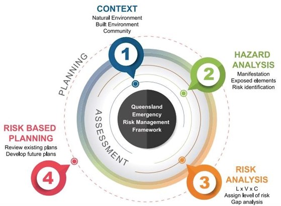
Queensland Emergency Risk Management Framework (QERMF) Source:QERMF: Risk assessment process handbook [64]
These multi-hazard assessments are underpinned by hazard information from different national and state scientific agencies (Geoscience Australia, Bushfire CRC, CSIRO), international sources (Landsat thermal imageries) as well as from local council specific hazard studies when available (flood, storm-surge, erosion, bushfire etc.). In conducting these studies, we consult with all organisations that manage critical assets within our communities. We build an understanding of their assets that are at risk and their capacity to manage different types and scales of disasters and identify capacity gaps that need to be addressed going forward. Such organisations include electricity providers, water supply and waste management agencies, telecom providers, hospitals, transport agencies, emergency services, Red Cross etc. Our team combines quantitative geospatial analysis along with extensive qualitative consultation with critical infrastructure stakeholders to understand vulnerability and risk and identify any existing capacity gaps that need to be filled to increase resilience going forward.
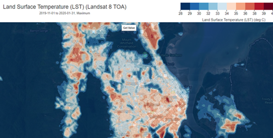
Landsat thermal images illustrating urban hotspots where temperatures are likely to be felt higher than other part of the city during a heatwave
Appropriate planning and preparation to manage natural disasters will save lives going forward under future climate extremes. A multi-hazard approach helps us to understand complexity in disaster management and help emergency managers, their stakeholders and their communities to develop appropriately focused plans to address the different phases of disaster management, planning, prevention, response and recovery.
It also becomes increasingly important for people to be climate literate when considering whether to buy certain properties. There’s a need for people to make their own decisions and determine their own risk but you need data. In some places it’s easy to access and in others it’s not as obvious. As risks increase homeowners may battle to get the insurance they require, or finance from banks. Insurance and finance sectors are aware of the risks they face, and they won’t insure or fund high-risk places that might not be there in the future.
We have been involved in the development of the CoastAdapt website developed by Griffith University’s National Climate Change Adaptation Research Facility, which provides maps showing potential climate impacts around Australia. As climate related events continue to worsen the reality is that people need to consider where they are buying.


